Climate change
A view into Nuestra Senora’s past
|
For a view into the river and its history, check out Dan Scurlock’s 1998 report, “From the Rio to the Sierra: An Environmental History of the Middle Rio Grande Basin.”
New Mexico In Depth (https://nmindepth.com/author/paskus/page/2/)
For a view into the river and its history, check out Dan Scurlock’s 1998 report, “From the Rio to the Sierra: An Environmental History of the Middle Rio Grande Basin.”
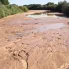
Continued high temperatures have also led to an expansion of drought conditions in the state. And as forecasters anticipate La Niña conditions for the fall and winter, everyone is hopeful that the last two months of the monsoon season will bring some relief.
Whether these are rural newspapers, daily weather reports on television, or the state’s largest paper, not giving readers information about climate change – and what scientists are anticipating will occur in New Mexico as the region continues warming – does a great disservice to the public.
This week the state agency in charge of building a diversion on the Gila River has scaled down plans for capturing the river’s water. The agency’s decision might mean good news for project critics who feared its environmental consequences and high cost. But many questions remain around how much money the state has to build the project, the location and scale of the diversion, and who would buy the water once it’s built.
For three decades, reporter John Fleck wrote about crisis. Now, in his new role as author and faculty member in the University of New Mexico Water Resources Program, he’s figuring out how to solve the same problems he reported on before leaving the Albuquerque Journal last year.
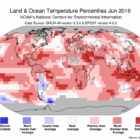
At a water conference at UNM last Friday, Dr. David Gutzler brought some bad news: Not only did El Niño bring less moisture than anticipated, La Niña may be on its way back. It’s still early to say that those warmer, dryer conditions are heading to the Southwest, but it’s clear that there’s no end to the state’s water management challenges.
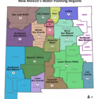
The New Mexico Interstate Stream Commission has released its draft regional water plans. Taken together, the 16 plans offer an overview of the state’s economy and its water resources–and they don’t paint a pretty picture.
On the latest episode of Blue Corn Live, a new podcast exploring food in New Mexico, farmers from the Albuquerque area talk about some of the challenges they face, including when it comes to climate change.
The following list provides key data related to 16 regional water districts in New Mexico, and a link to a draft water plan for each region. The draft plans are part of a years-long process to develop both regional and a comprehensive state water plan for New Mexico. More information can be found on the website of the State Engineer. Also read New Mexico In Depth’s accompanying story, Regional water plans reveal sobering future. Region 1: Northeast New Mexico Region
Counties include: Union, Harding, Quay, Curry, Roosevelt
Size: 9,700 square miles
Population: 84,278
Per capita income range: $18,086 (Roosevelt County) – $21,179 (Curry County)
Primary source of water: 87% comes from groundwater
Total annual water use: 528,448 acre-feet per year
Primary water use in region: 89% of total water usage goes toward agriculture
Read the Region 1 draft water plan.

Officials aren’t talking about New Mexico’s efforts to cut carbon emissions under the federal Clean Power Plan.