New Mexico’s inaugural use of a nonpartisan committee in the once-a-decade political tradition that will reshape state elections for the next 10 years could mark a milestone Friday.
The seven-member committee created by state lawmakers earlier this year is scheduled to select maps that would redraw the boundaries of legislative and congressional political districts and send them on to New Mexico’s 112 state lawmakers. The process is undertaken after each U.S. Census to ensure political districts represent roughly the same number of people.
New Mexico’s new Citizens Redistricting Committee’s recommendations are non-binding. State lawmakers will decide whether to accept or reject them and approve different plans when they meet in Santa Fe in December. But the committee’s monthslong process of collecting public input from hundreds of New Mexicans and disparate groups provides a window into choices before the Legislature.
Whatever plans are ultimately adopted, the stakes are high, with final maps having the potential to remake politics in New Mexico and impact the balance of power in Congress for the next decade.
Republicans fear that Democrats, who have near-total control over the redistricting process for the first time in 30 years, will take advantage of the opportunity to redraw lines that make it easier for them to win while disenfranchising GOP voters, especially in the southern Congressional district that leans Republican now.
Other groups say that the committee has opened an opportunity for long neglected communities of interest to better push for districts that serve them.
The independent, nonpartisan Citizens Redistricting Committee, modeled on similar nonpartisan bodies across the country, including in states such as Colorado and California, was born out of compromise, giving its members a say in the state’s redistricting process but not taking final approval out of the hands of state legislators. People across the political spectrum are commending the work it did this year..
“The committee is doing admirable work, it’s a very august group of people,” said Robert Aragon of the state Republican Party, which he said would offer its own proposed maps.
Mason Graham and the newly-formed Black Voters Collaborative got involved in redistricting for the first time this year and Graham said he felt his group’s concerns were genuinely heard. “The committee was invested in the process and invested in making sure that the representation was equal,” he said. After giving testimony on the proposed maps, members of the committee suggested the group elaborate on its ideas by submitting its own map, which it did.
Many have appreciated the transparency of the process. “The CRC has provided another layer of advocacy that the Pueblo leadership really appreciates,” said Casey Douma, co-chair of the All Pueblo Council of Governors Ad Hoc Redistricting Committee. “It brought the process out of the back rooms and put it on full display in public, which is very good.”
The CRC met nearly twice as many times as the Legislature’s interim redistricting committees have in past years, traveling beyond Albuquerque, Santa Fe and Las Cruces to Farmington, Roswell, Española, Gallup and Crownpoint. Unlike former legislative hearings, the CRC webcast the meetings and the public was invited to testify in person or on Zoom, to upload written comments or use interactive software, called Districtr, to draw their own maps.
Simple and user-friendly, Districtr alone has made a big difference in people’s ability to share their ideas. “Ten years ago those who had access to the software could act as gatekeepers and if you didn’t have access you were left out,” Douma said. “It’s a game-changer.”
Those practical and technological changes are welcome among good government groups. “We’ve had tremendous input,” said Kathleen Burke of Fair Districts New Mexico, a coalition that includes Common Cause, the League of Women Voters, New Mexico First and the New Mexico Foundation for Open Government. “People have become educated and they are rising to the occasion to change the status quo.”
And yet, when state lawmakers meet to vote on maps in December, nothing will prevent them from doing things the way past participants say they always have: by breaking into Democratic and Republican caucus meetings that are closed to the public, and drawing maps that benefit themselves and their parties.
Not everyone is so sanguine about the public input process. “I’m not sure what any of these people are going to accomplish,” said former Republican state Sen. Rod Adair, a demographer who has worked on several rounds of redistricting. “The majority is going to produce whatever maps they want and all the Republicans can do is stomp their feet,” he said.
Several of the best-organized groups who have submitted maps and testimony, including the All Pueblo Council of Governors, represent largely voters of color who mostly vote Democratic. And because the federal Voting Rights Act prohibits racial gerrymandering, their testimony carries special weight. These are the folks who might sue if they believe minority voting rights have been infringed by the new maps.
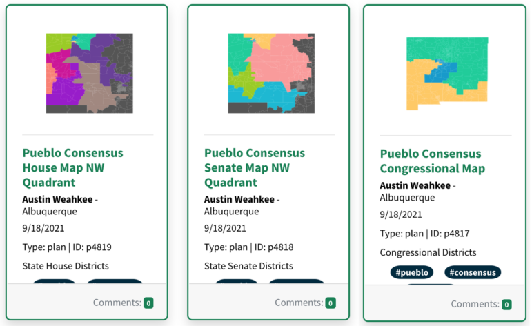
Both the All Pueblo Council and the Center for Civic Policy, a progressive public policy organization, submitted plans that provide a template for how to radically change the state’s congressional districts.
And Aragon charges that they favor Democrats, especially in the traditionally Republican southern congressional district.
The CCP plan creates a solid Hispanic voting-age majority district in an eye-catching way, bringing a finger of the northern district down to the edge of Hobbs; shifting the South Valley of Bernalillo County to the southern district, and combining most of Albuquerque with parts of nine counties to the south and east, reaching past Roswell and Ruidoso.
The All Pueblo map adds Rio Rancho and most of Socorro County to the first congressional district which includes Albuquerque, and shifts the South Valley, and parts of Laguna Pueblo and To’Hajiilee (Navajo) to the southern district. What’s most contentious is the proposed move of Santa Rosa, Fort Sumner, Roswell, Ruidoso and part of the Mescalero Apache Nation out of the southern district to the north.
“Their maps ensure one party has an absolute advantage over the next 10 years and that’s not good governance,” Aragon said.
But partisan politics aren’t the reason for the proposed changes in the All Pueblo map, said Pueblo representatives.
“There’s a reason why the map does that,” said Keegan King, co-chair of the All Pueblo Council redistricting group. The Council did not look at performance data, which gives detailed insight into how precincts perform politically, in preparing its maps, King said.
The northern district reaches so far south in order to give the Mescalero Apache influence in two congressional districts, as Zuni Pueblo does now, he said.
“We want to consolidate voting power in some places but in others we don’t want to pack all that power into one district,” he explained. “It is important for tribes to be able to say what a community of interest looks like and also to say we need additional representation.”
Those in power have historically neglected the voices of tribal nations, Douma argued, and the All Pueblo Council’s maps are the result of a long process of engagement that resulted in a consensus among the 19 pueblos and the Jicarilla Apache. (The Navajo Nation has submitted separate plans.) Any plans put forth by the committee and the Legislature should be evaluated accordingly. “Ultimately, what will give validity to those concepts is their ability to incorporate our maps,” Douma said.
The Black Voters Collaborative didn’t submit a Congressional map, focusing its effort instead on protecting and strengthening the influence of Black and African American voters in areas including Albuquerque’s International District, Hobbs, Alamogordo and Clovis.
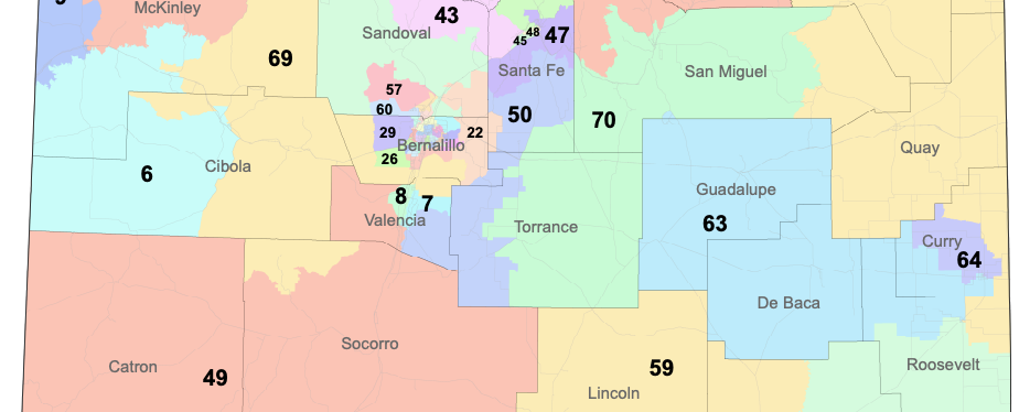
Graham said the group’s main goal was to make sure that Clovis had appropriate representation for its Black community of about 2,000, which includes a significant number of people serving at Cannon Air Force Base. Their proposed map adjusts the boundaries of state House districts 63 and 64 slightly to more equally balance the population between the two districts. Black voters would make up less than 5% of the voters in each district but their hope is to encourage Black candidates to run.
Plenty of Republican groups and individuals have given powerful testimony, Burke said. “They are making their voices heard, too, maybe not in the same numbers, but they are showing up with good arguments and good reasons to have their districts drawn the way they propose.”
All of this falls in the laps of the seven CRC members who have been listening to testimony, taking notes and working on their own draft maps with contract demographers from Research and Polling Inc. This Friday, members will put the proposals on the table and debate.
“There’s no such thing as a perfect map,” said CRC chair and former state Supreme Court Justice Edward Chavez. But he’s hopeful that the group will be able to sift through all the proposals and complete their mission to approve at least three maps each for the state House, state Senate, Congress and Public Education Commission.
He said he’s pleased with the committee’s work in collecting the public’s ideas and responding with new maps that incorporate those ideas for a second round of public meetings. “So if we are able to agree on maps that provide the Legislature with some options that comply with the Voting Rights Act and preserve as many communities of interest as we can, then I think they’re going to select one of them.”
What a ridiculous waste of time and money, Egolf and his cronies in the Santa Fe Ring will make all decisions.
Top of page: Finally, an accurate map of the State of New Mexico showing the true southern boundary of the state.
Thank you.